Nvidia Jetson/Orin + FPGA + High-Compute AI Edge Box for Smart Landscape Monitoring Solution
Project Background
Guided by the concept that "lucid waters and lush mountains are invaluable assets," the nation has put forward the "14th Five-Year Plan for Forestry and Grassland Protection and Development." This plan aims to improve the management level of national parks by conducting surveys, confirming registration, and demarcating boundaries for natural resource assets. It also seeks to establish an integrated "space-air-ground" monitoring system, implement protection and restoration of natural ecosystems, protect flagship species and restore their habitats, construct ecological corridors, and protect and restore natural landscapes and cultural heritage sites.

Industry Requirements
- Comprehensive resource surveys, dynamic supervision, and performance evaluation.
- Effective prevention and control of major disasters and harmful organisms.
- Scientific conservation of biodiversity.
- Comprehensive safety assurance for park operations.
- Continuous optimization of public service quality.
- Efficient improvement of business processes and efficiency.
Solution
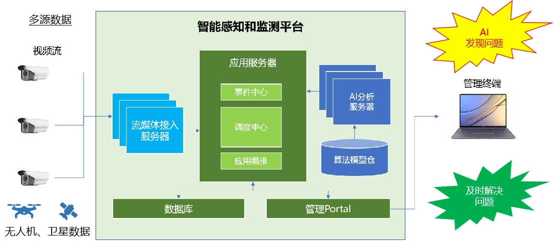
In response to policy calls and market demands, Xinmai Technology partnered with a software company to design an advanced smart landscape monitoring solution, and successfully created an integrated "space-air-ground" intelligent sensing and monitoring platform.
The platform utilizes AI image analysis technology, integrating multi-source data from satellite remote sensing, drones, and video surveillance. It achieves real-time, comprehensive monitoring of ecological resources, continuously monitoring and identifying species information such as plants, birds, wildlife, insects, and aquatic organisms. This builds a foundational database of biodiversity resources and generates activity reports for birds and wildlife. Whether it's resource protection incidents, biodiversity information, or disaster warnings, the platform can respond quickly, enhancing ecological resource protection capabilities.
Space: Using remote sensing imagery from different payloads carried by satellites, the platform regularly monitors large-scale forest resources. It can analyze forest health, assess the impact of ecological pressures such as drought and pests, and conduct forest cover change analysis, carbon stock estimation, etc.
Air: Utilizing Xinmai-equipped drones for automatic scheduled patrols, the platform efficiently collects image data in patrol areas difficult for personnel to reach, transmitting data back to the analysis center. This can be used for forest fire prevention, pest and disease early warning, wildlife monitoring, etc., increasing observation frequency and density, and reducing labor intensity for personnel.
Ground: Employing comprehensive methods such as IoT, fire monitoring, video surveillance, insect pest forecasting, smart checkpoints, vehicle patrols, and mobile patrols, the platform weaves a dense monitoring network.
Solution Advantages
1. Multi-source Data: Compatible with various video/image data sources, achieving full coverage for intelligent monitoring, enabling timely notification of results and feedback on issues; simultaneously aiding in biodiversity data accumulation.
2. Intelligence: Relying on deep learning technology, the platform provides high-precision, high-efficiency image analysis models, including classification models, object detection models, semantic segmentation models, instance segmentation models, etc., possessing industry-leading accuracy and execution efficiency, supporting various AI applications.
3. Automation: A powerful automatic scheduling mechanism ensures a stable and reliable system, capable of processing thousands of tasks simultaneously, achieving automation in intelligent monitoring.
4. Openness: Supports access for multiple brands and models of cameras; offers an open algorithm model repository, supporting access for third-party and proprietary model libraries; flexible and convenient application orchestration.
5. Optimizable: Users can perform secondary optimization on algorithms and models according to their needs, meeting personalized accuracy requirements.
Customer Benefits
1. Upgraded Ecological Resource Protection: Through a multi-dimensional intelligent sensing and monitoring platform, achieve pre-judgment, in-process supervision, and post-event evaluation, comprehensively reducing resource damage and disaster risks.
2. Significantly Improved Work Efficiency: Data-driven decision-making and assessment comprehensively enhance the work efficiency of personnel at all levels and reduce labor costs.
3. Enhanced Governance Refinement: Optimize business processes through digital means, reduce human interference, and improve the refinement of governance.
4. Enriched Application Scenarios: Systematically build industry datasets and algorithm model libraries, enabling in-depth application in sub-fields such as resource monitoring, disaster prediction and early warning, operational risk monitoring, and biodiversity, thereby expanding smart city application scenarios.